Twenty-mule teams were teams of eighteen mules and two horses attached to large wagons that ferried borax out of Death Valley from 1883 to 1889. They traveled from mines across the Mojave Desert to the nearest railroad spur, 165 miles away in Mojave. The routes were from the Harmony and Amargosa Borax Works to Daggett, California, and later Mojave, California.
After Harmony and Amargosa shut down in 1888, the mule team’s route was moved to the mines at Borate, 3 miles east of Calico, back to Daggett. There they worked from 1891 until 1898 when they were replaced by the Borate and Daggett Railroad. The wagons were among the largest ever pulled by draft animals, designed to carry 10 short tons (9 metric tons) of borax ore at a time.
As it has been for a century or more, minerals are excavated from the desert and hauled away for the purposes of man. I do wonder if these truck drivers know of the legacy that they represent. It wasn’t that long ago when a mule skinner and swamper might have made the same long hot trip on a wagon led by 18 mules and 2 horses.
Composite by John Earl
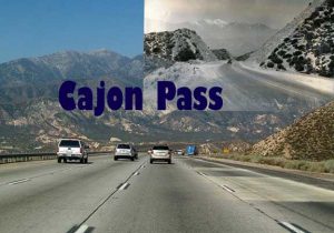
Conquering the rugged terrain of Cajon Pass at Summit for the National Trails Highway (Rout 66) was no easy task before 1930.Cajon Pass islaced with faults and composed of decomposed granite, schist, and other soft, somewhat crumbly rocks, which tends to slough off in wet years.
Route 66 over Cajon Pass in the 1950s also claimed the names of Route 91 and Route 395. Highway 91 originated in Sweetgrass, Montana, and ended at Highway 101 in Los Angeles. Now Highway 91 ends in Barstow, California. Highway 395 also began near the Canadian border north of Laurier, Washington, and extended to San Diego. Now it ends at the I-15 near Hesperia, California.
Composite by John Earl
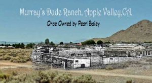
At the northwest corner of Waalew Road and Dale Evans Parkway in Apple Valley, just across the road from the Los Ranchos Mobile Home Park, is a vacant piece of desert with a few cement foundations and a smattering of trees.
Next time you drive by there you might want to know that in the 1940s and 50s it was a working ranch of a special sort. Known as “Murray’s Ranch,” and “The Overall Wearing Dude Ranch,” it was African-American owned and operated, and was open to one and all.
The setting for many many western films of the era, Murray’s was also a getaway for film and radio celebrities of all backgrounds. In fact, in 1955, the ranch was purchased by none other than Pearl Bailey, who had fallen in love with the area and the ambiance.
By the 1980s, the ranch was virtually forgotten and in 1988 the building were intentionally burned to the ground in a fire fighting exercise.
Upper photo courtesy of Calisphere. Composite by John Earl
They were there in 1863. We were there yesterday. Just 153 years later. Shown in the inset, mine workers passing through. The Mojave Road. It still stirs the imagination like few other places in this amazing desert.
Before the railroad came along in the years after the Civil War, the Mojave Road was the preferred, and often dangerous, route from all points east, to the Southern California coast. It was a tough way to travel.
Rock Spring was an important stop along the trail. So much so that the U.S. Army designated it an official military post.
Composite by John Earl
Bear Flats way station was leased to Jesse Tay and Charles Lawrence in 1879 and renamed Cozy Dell. It remained an important traveler oasis with buildings on both sides of the road even through Route 66 years. Philip Hanf, the cook, became owner in 1902. The road followed the foothills on the west side for a short distance before it crossed Cajon Canyon to wend through Cozy Dell.
In 1926, the Old Trails Highway was renamed Route 66 and became “the Mother Road,” linking Chicago, Illinois, with Venice, California. The original route was paved in 1916 to Devore by May with macadam, continuing to Cozy Dell by summer–the first paved highway.
Now, Route 66 in this area serves as a bypass from busy Interstate 15. There are no longer any services. The only two exits off the freeway to 66 are Cleghorn and Kenwood, between Highway 138 and the 15/215 split, so if you miss either, you’re stuck.
Composite by John Earl
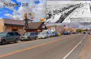
Oro Grande, California, located on the Mojave River, was the location for Native American settlements hundreds of years. The river was also the part of a trade route from the Colorado River for tribes in the southwest with those on the coast of Southern California, what was called the Mojave Trail.
Followed by Spanish padres and soldiers, and later American fur trappers and New Mexican traders the Mohave Trail became part of the Old Spanish Trail between New Mexico and California from 1830.
The town was named after the first mine found, the Oro Grande Mine. The first houses were built and a post office established called Halleck in January 1881. A stamp mill for these mines was installed on the river, and later used for those of Calico.
From 1887, limestone quarries opened and two kilns were produced lime for cement. From 1907, cement was made in Oro Grande. Marble was also mined. On May 25, 1927, the post office officially was renamed as Oro Grande.
Composite by John Earl
You are welcome to see what you will when you look across a barren patch of desert. For me, I see the past. It’s ever present in my mind. Mohave Indians were there when I looked today.
This Paiute winter dwelling house was known a “siwanopi”, house of straw. A smoke hole at the top at the thatched or canvas roof drew fumes from its interior.
Composite by John Earl
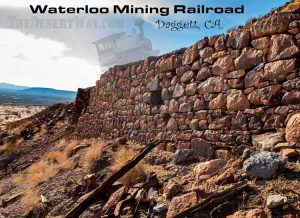
For about 15 years, starting in 1888, the Waterloo stamp mill on the side of Elephant Mountain in Daggett processed ore from the Calico mines, eleven miles away. The ore was hauled to the mill by the Waterloo Mining Railroad, a narrow gauge train that ran along this steep treacherous mountain.
All that remains can pretty much be seen in this photo as the ghost of Engine Number 2 makes another trip back to Calico, California.
Composite by John Earl
On 8 June 1966, a experimental bomber, the XB-70 Valkyrie, fell to earth on this exact spot after colliding with an F-104 chase plane north of Barstow, California.
The pilot of chase plane, NASA test pilot Joseph Walker, was killed when his jet exploded in midair after hitting the large supersonic bomber. The XB-70, piloted by USAF Major Carl Cross, was killed on impact.
All in the name of filming a General Electric commercial showcasing jet engines. The desert recovers but memories remain.
Composite by John Earl
Camp Cady was established during the Bitter Spring Expedition in 1860, by Major James H. Carleton, and Company K, 1st U.S. Dragoons, as a base camp for Carleton’s campaign to punish Paiute who had attacked travelers at Bitter Spring on the Los Angeles – Salt Lake Road. Camp Cady as named for Major Albermarle Cady of the 6th U.S. Infantry.
After the Bitter Spring Expedition, Camp Cady was garrisoned of and on until it was abandoned for a time in early part of the American Civil War after Fort Mohave was abandoned on July 3, 1860. It was reestablished by the California Volunteers on April 23, 1865 and abandoned a second time on April 1, 1866 but due to Indian depredations it was reestablished the next month. It remained manned until 1871, at which time it was abandoned permanently by the military.
Adobes on the property were “melted” when the Mojave river flooded in 1938. Camp Cady Wildlife Area is 1,870 acres of desert riparian habitat, consisting of screwbean mesquite, tamarisk, willow, cottonwood, saltgrass, saltbush, and cattails along the Mojave River, which passes through the center of the wildlife area. Volunteers from Quail Unlimited are on site as caretakers of the buildings and grounds.
Composite by John Earl
It’s been many long years since the age of steam locomotives. They were the high tech marvel of their age. Still, if you’re ever in Afton Canyon, and let your imagination take over you might still see a Union Pacific loco racing through on its way to Las Vegas and beyond. Do you hear the huffing of the engines and the long shrill whistle as it approaches?
Thank you for joining us for our first installment of many to come focusing on the Mojave Desert’s amazing past and present. If you have a particular area of interest, please send your suggestions to us. If it’s not already in our archives, we will be glad to put a short piece together about it and feature the area and history in future articles.
Citations and Recommended Resources:
The Twenty Mule Team of Death Valley by Ted Faye
The Cajon Pass by Alice Eby Hall
Route 66 in California by Glen Duncan & the California Route 66 Preservation Foundation
Mojave Road Guide, An Adventure Through Time by Dennis G. Casebier
3 thoughts on “A Trip Through Time: The Mojave Desert Then and Now, Part I”
I really enjoy going àlong with you through the dezert. I use to go to Aftonbladet Canyon when I was a girl. There use to be a cafe there, and the school bus was there that I use to ride. I use to visit the people that lived there and ran the cafe. I use to go down by the railroad trakes, there was a stream there, and I use to catch minnows. I lived 3 miles from there, (towards Yermo.) Actually, we moved to Yermo, and that’s where I grew up,so a lot of the places you talk about, and have been, I have been. So keep on travelin’,
What great memories, Judy! Thanks for sharing them for all of us to enjoy. It sounds like you had a great childhood. And just think. You did it all without Pokemon Go.
That’s pretty amazing thank you for your memory…it’d be spectacular if you had pics to go along with it =)